Route 66 in New Mexico marks a noticeable shift in character, where the landscape and cultural identity begin to reflect the American Southwest. The road feels less defined by distance alone and more shaped by place—through adobe architecture, earth-toned color palettes, and the enduring presence of Indigenous cultures that grounded the region in a deeper sense of history.
This page highlights selected locations and experiences along Route 66 in New Mexico, focusing on places that reveal the character of the route rather than attempting to document every stop along the way.
The Character of Route 66 in New Mexico
Route 66 in New Mexico takes on a distinct regional identity. The road moves through desert landscapes, historic towns, and areas shaped by Native American, Spanish, and Anglo influences. This layered cultural presence gives the journey a sense of depth that feels different from the stretches that come before it.
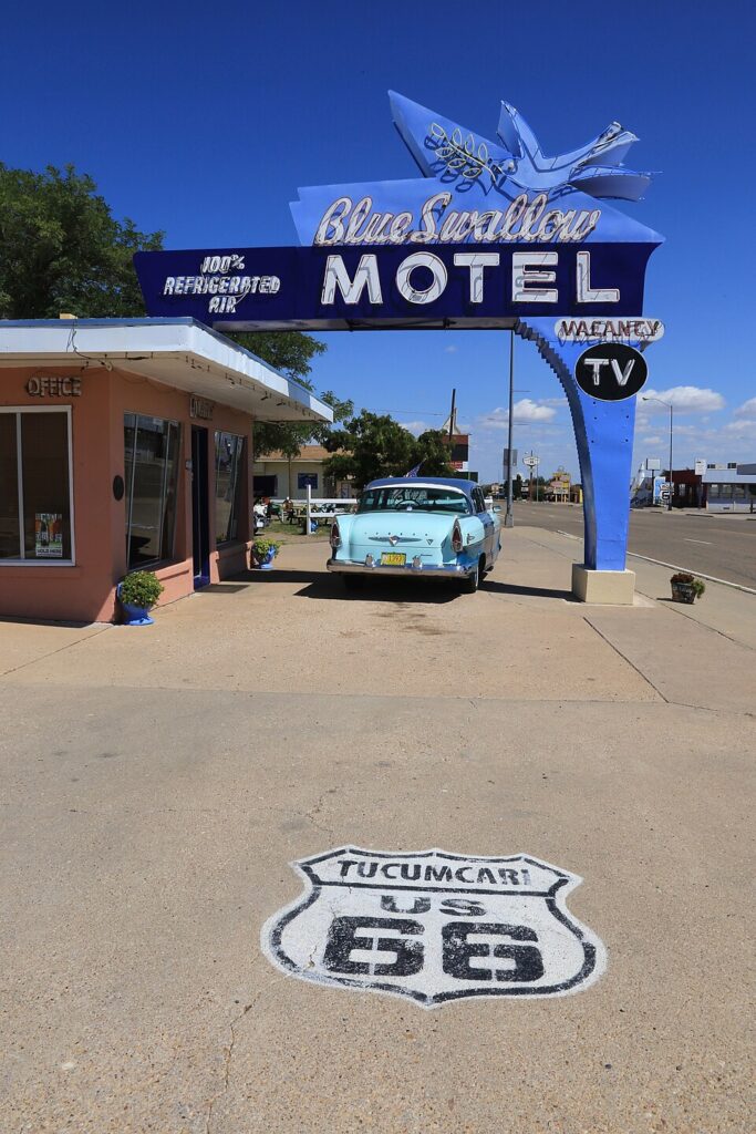
Blue Swallow Motel — Tucumcari
This restored motel stands as one of the most iconic and well‑preserved examples of Route 66 lodging. Its neon sign and garages reflect a time when overnight stops were designed with both function and visual appeal.
The Blue Swallow Motel in Tucumcari, New Mexico, has welcomed Route 66 travelers since 1939, its neon sign among the most iconic on the entire highway. Photo: Jennifer A. Walz, CC BY-SA 4.0 https://creativecommons.org/licenses/by-sa/4.0, via Wikimedia Commons
Behind that neon sign is one of the most beloved names on Route 66. Lillian Redman first came to New Mexico in 1915, traveling with her family in a covered wagon, and later worked as a “Harvey Girl” — one of the young waitresses employed by Fred Harvey’s famous chain of railroad hotels and restaurants across the American West. In 1958, her husband Floyd bought the Blue Swallow Court as an engagement present, and together they renamed it the Blue Swallow Motel, installing the swallow-shaped neon sign that’s now one of the most photographed landmarks on the entire highway.
When Floyd died in 1973, Lillian kept the motel running alone for another 25 years — through the years that hit Route 66 hardest, after Interstate 40 diverted through-traffic away from Tucumcari and the town’s motel count collapsed from over 2,000 rooms to a fraction of that. She never closed the doors. When guests couldn’t afford a room, she was known to accept whatever they had — a wristwatch, a trade, sometimes nothing at all — and simply let them stay. “I end up traveling the highway in my heart with whoever stops here for the night,” she once said. Her portrait still hangs in the lobby today, and one of the suites carries her name.
The motel’s influence reaches beyond Route 66 itself, too — the town of Tucumcari inspired the mountain silhouette in Pixar’s Cars, and the Blue Swallow’s neon swallow is widely credited as inspiration for the film’s Cozy Cone Motel.
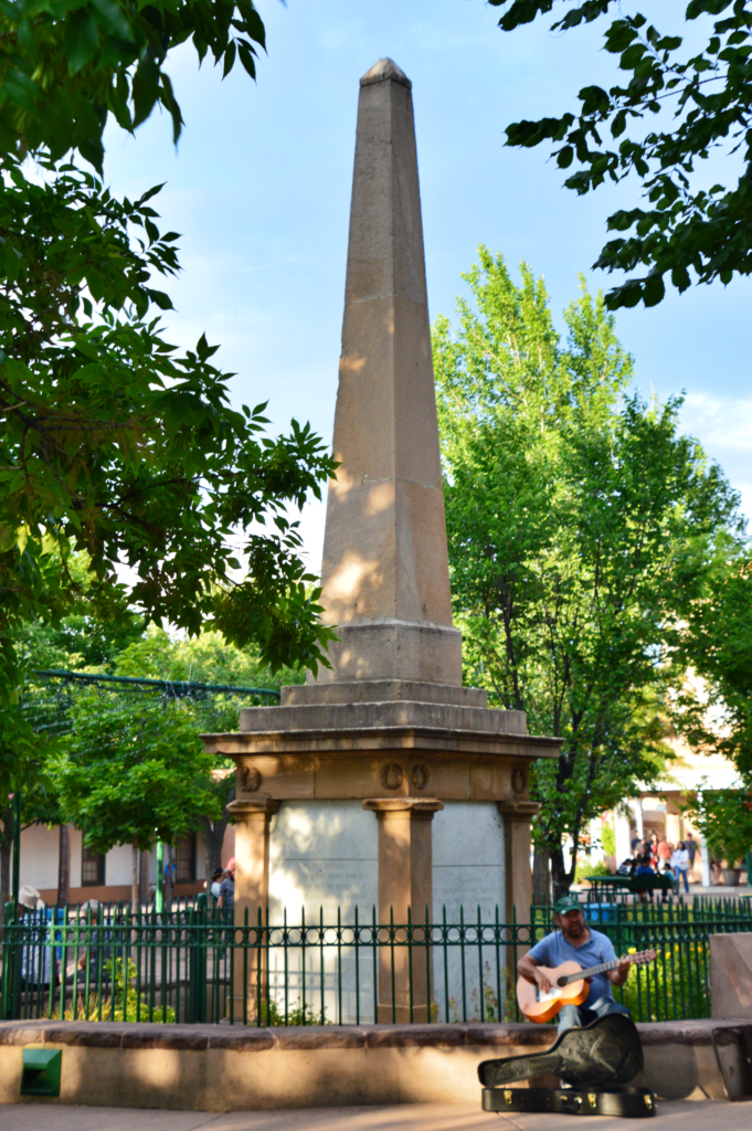
Santa Fe Plaza — Santa Fe
Unlike many Route 66 stops, Santa Fe introduces a different rhythm shaped by adobe architecture, art, and long‑standing cultural traditions. Its inclusion reflects a historic alignment of Route 66 that once passed through the city.
From 1926 to 1937, Route 66 didn’t run straight across New Mexico — it curved north out of Santa Rosa, wound through Santa Fe along the old Santa Fe Trail, then doubled back south toward Albuquerque before continuing west. The detour added real mileage, and it existed largely because Santa Fe was the political and cultural center of the state at the time.
Santa Fe Plaza marks the original Route 66 alignment before the highway was rerouted south through Albuquerque in 1937.
That changed because of a grudge. In 1927, outgoing governor Arthur T. Hannett, convinced Santa Fe’s political establishment had cost him reelection, used his final weeks in office to order a direct road built from Santa Rosa straight to Albuquerque — bypassing Santa Fe entirely. It took ten years for the federal government to formally adopt “Hannett’s Joke” as the official alignment, but in 1937, Route 66 was rerouted for good: straight, efficient, and about 100 miles shorter, running through Albuquerque’s Central Avenue instead. Santa Fe’s Route 66 tourist trade dried up almost overnight.
By most accounts, the city didn’t mind much. Santa Fe simply went on being Santa Fe — a capital, an art colony, a destination in its own right, road or no road. Walk the Plaza today and you’re standing on what was, for eleven years, one of the most scenic detours the Mother Road ever took, even if it no longer carries the name.
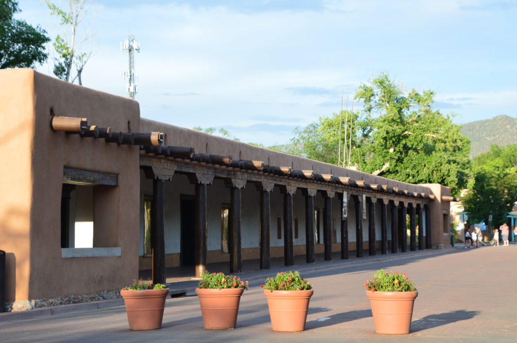
The Palace of the Governors in Santa Fe — built in 1610, it’s the oldest continuously occupied public building in the United States, and it once sat along Route 66’s original alignment through the city.
Just off the Plaza stands the Palace of the Governors, built in 1610 as the seat of Spanish colonial government — making it the oldest continuously occupied public building in the United States. Under one roof, it has served four different governments: Spain, Mexico, the Confederacy (briefly, during a few chaotic weeks in 1862), and the U.S. Territory of New Mexico, before New Mexico became a state in 1912. Over a hundred governors have called it home in one form or another.
It’s also held its share of unexpected history. Territorial governor Lew Wallace reportedly wrote the climactic crucifixion scenes of Ben-Hur here, working by lamplight during a thunderstorm in 1879, not long after a tense meeting with Billy the Kid. Today, Native American artisans sell handmade jewelry and crafts along the building’s long portal, much as they have for generations — a quieter kind of continuity in a building that has otherwise seen its share of upheaval.
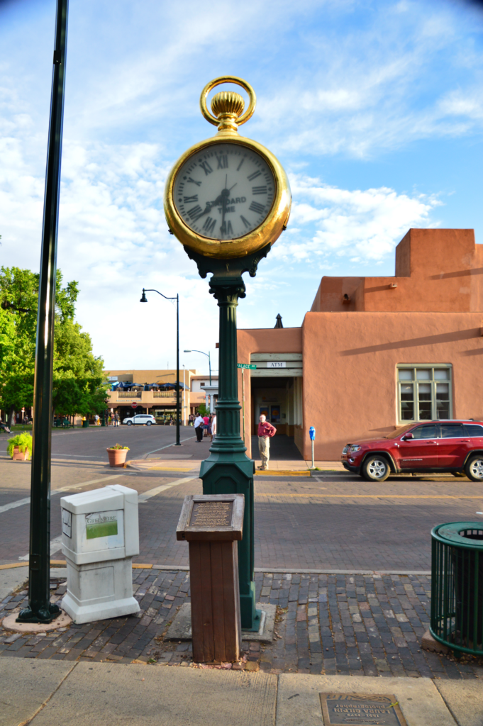
A block off the Plaza stands a landmark that has outlived two versions of itself. The Spitz Clock — a giant gold pocket watch mounted on a green iron post — has marked this corner since the Spitz Jewelry Store first opened in 1881. The original wasn’t even a real clock; it was a hollow advertisement, just a shell shaped like a timepiece to catch the eye of passersby. A working version eventually replaced it, only to meet an unglamorous end in 1915, when one of Santa Fe’s very first motor trucks lost control on the Plaza and flattened it.
The Spitz Clock has marked this corner near Santa Fe Plaza since 1916 — the third clock to stand here, and reportedly the only Howard street clock left with its original gears intact.
Undeterred, jeweler Salamon Spitz bought a secondhand replacement clock from Kansas City in 1916 — the one still standing today. Built by the E. Howard Company, it’s believed to be the only surviving Howard street clock in the country with its original gears still intact. It stood watch outside the jewelry store for another five decades before construction forced it into storage in 1967. Seven years later, the Spitz family donated it back to the city, and it was re-erected near the Plaza in 1974, where it has stood ever since — gold-leafed, a little weathered, and still telling time the old-fashioned way.
Old Town Albuquerque — Albuquerque
This historic district offers a walkable environment where architecture, public spaces, and local businesses reflect the cultural blend unique to New Mexico. It provides a contrast to the roadside stops more commonly associated with Route 66.
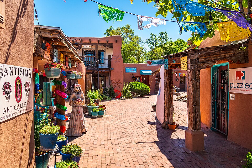
Old Town Albuquerque’s adobe walkways are lined with galleries, shops, and folk art. Photo: dconvertini, CC BY-SA 2.0 https://creativecommons.org/licenses/by-sa/2.0, via Wikimedia Commons
Old Town has been here since 1706, when Spanish governor Francisco Cuervo y Valdés laid out the original plaza, following Spanish colonial law that required every new settlement to be built around one. For nearly two centuries, it wasAlbuquerque — homes, shops, and government offices all clustered around the plaza and the San Felipe de Neri Church.
Then, in 1880, the railroad arrived and bypassed the Plaza entirely, choosing higher ground about two miles east instead. Almost overnight, a rival “New Town” sprang up around the tracks, pulling businesses and momentum away from the original settlement. By the 1930s, Old Town had faded into quiet disrepair — barely a handful of businesses remained open around the plaza that had once been the entire city.
It took local preservationists rediscovering the neighborhood’s value in the 1940s to turn things around. Old Town was formally annexed by the city in 1949, finally bringing paved streets and modern improvements, and its old adobe homes were gradually restored and reopened as the shops, galleries, and restaurants that fill the district today. What almost became a ghost town is now one of Albuquerque’s most visited destinations — a reminder that even Route 66 itself, decades later, would end up rerouting straight through the city that once left this neighborhood behind.
San Felipe de Neri Church — Albuquerque
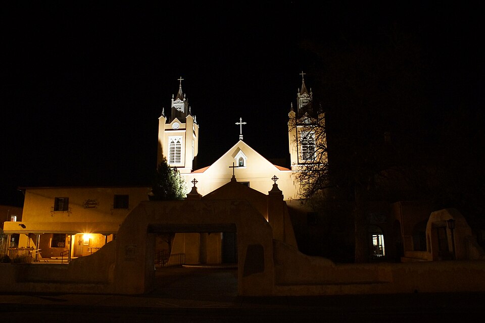
Behind those illuminated bell towers is a church that has already rebuilt itself once. The original San Felipe de Neri, established in 1706 alongside Albuquerque’s founding, stood for nearly ninety years before a brutal rainy summer in 1792 finally caused it to collapse — its adobe walls simply eroded away. The provincial governor called the collapse a disgrace and ordered the surrounding community to help rebuild immediately. Villagers from Tomé and Valencia did most of the work, and the new church — the one still standing today — was completed the following year, in 1793, with adobe walls five feet thick.
San Felipe de Neri Church has anchored Old Town Albuquerque since 1793. Photo: Chris English, CC BY-SA 3.0 https://creativecommons.org/licenses/by-sa/3.0, via Wikimedia Commons
The building has kept adapting ever since. When Bishop Jean-Baptiste Lamy arrived from France in the mid-1800s, he found the plain adobe church too simple for his taste and pushed for a more European look — the twin bell towers you see today, along with pointed Gothic arches, were added around 1861, essentially dressing a Spanish colonial adobe structure in a Victorian costume. Later renovations added a decorative gable, a “widow’s walk” along the roofline, and a pressed-tin ceiling inside.
The result is a building that wears its whole history at once — Spanish colonial bones under a Gothic Revival skin — and it’s now the oldest surviving structure in Albuquerque, a landmark that watched the city grow up around it more than a century before Route 66 ever passed nearby.
KiMo Theatre — Albuquerque
An Art Deco landmark incorporating Pueblo Revival design elements, the KiMo Theatre reflects how architecture along Route 66 often adapted to regional styles rather than following a single aesthetic.
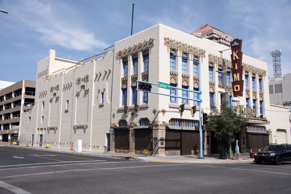
The KiMo Theatre in downtown Albuquerque, a striking example of Pueblo Deco architecture on Route 66. Photo: Gillfoto, CC BY-SA 4.0 https://creativecommons.org/licenses/by-sa/4.0, via Wikimedia Commons
Opened in 1927, the KiMo is one of the finest surviving examples of Pueblo Deco — a short-lived architectural style that fused Pueblo Revival forms with Art Deco flair, blending stepped adobe massing with the soaring vertical lines of a 1920s movie palace. It was the vision of Oreste and Maria Bachechi, an Italian-American couple who wanted the building to honor the Native American community that had welcomed their family. Even the name has a story: the Albuquerque Journal ran a contest to name the theater, requiring an “Indian name” of six letters or fewer, and Pablo Abeita, the former governor of Isleta Pueblo, won with “KiMo” — meaning “mountain lion.”
The building has weathered real hardship over the decades. In 1951, a boiler explosion in the lobby injured eight people and killed a six-year-old boy named Bobby Darnall, a tragedy that’s still remembered by the theater today. A 1963 fire later gutted the original stage, and by the 1970s the KiMo sat empty and slated for demolition before Albuquerque residents voted to buy and save it themselves. It’s been in careful restoration ever since — a building that, in its own way, has outlasted every setback thrown at it.
Blue Hole — Santa Rosa
A natural spring known for its deep blue water, the Blue Hole offers a different kind of stop along Route 66 — one shaped by geology and landscape rather than roadside development.
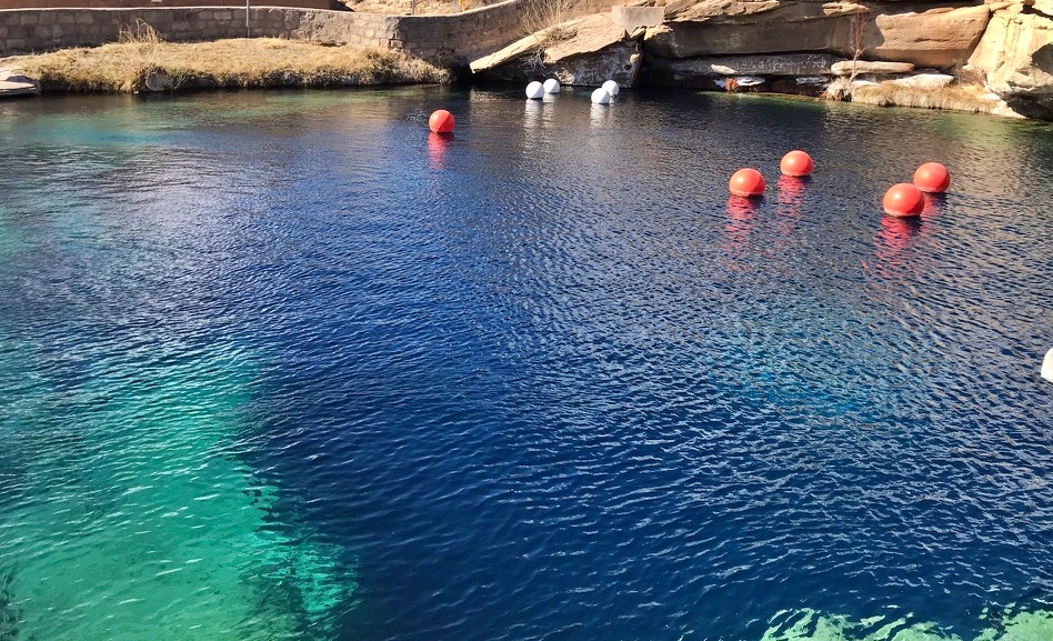
It’s genuinely unusual in scale: roughly 80 feet across at the surface, the pool widens to 130 feet at the bottom before dropping over 80 feet deep, fed by an underground spring pumping 3,000 gallons of water per minute — enough to completely replace the pool’s water every six hours. That constant flow keeps the water a steady 62°F year-round and gives it visibility that regularly exceeds 100 feet, which is part of why the Blue Hole has become one of the most popular inland scuba diving and training sites in the country, drawing divers from across the Southwest despite sitting hundreds of miles from any ocean.
The Blue Hole in Santa Rosa, New Mexico — a natural artesian spring known for its startling clarity and constant 62-degree water, long a favorite stop for Route 66 travelers.
The pool’s history predates the highway by a wide margin — it’s believed to have served as a water source for Indigenous peoples and cowboys for centuries before Route 66 travelers ever discovered it, and it briefly operated as a fish hatchery in the 1930s before becoming the recreation site it is today. Below the visible pool lies a sealed-off cave system, mapped to depths of nearly 200 feet, closed to the public since 1976 after two divers died exploring its passages. What’s left accessible is dramatic enough on its own: a small, self-contained world of clear blue water in the middle of high desert, unlike anything else along the entire route.
Roadside Culture & Landmarks
Route 66 in New Mexico reflects a shift in roadside culture toward regional expression. Neon signs and motels remain present, but they often incorporate local materials and architectural styles, creating a distinct variation where each stop feels influenced by the surrounding landscape and culture.
Traveling Through New Mexico
Traveling Route 66 in New Mexico introduces longer distances combined with changing terrain. The road alternates between expansive desert stretches and towns with strong local identities, creating a varied and often unexpected rhythm.
Elevation changes, light conditions, and weather can all influence how the road is experienced, making timing and pacing an important part of the journey.