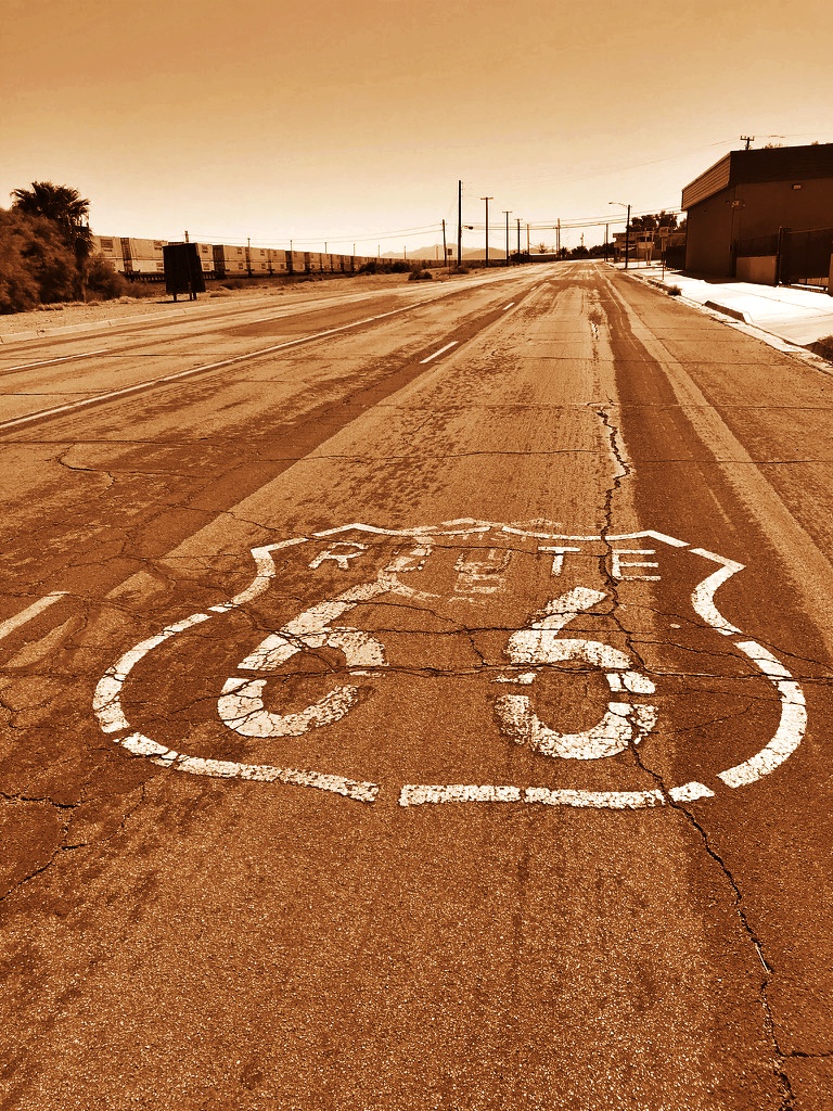
A weathered Route 66 shield marks the pavement in Needles, California — the Mother Road’s stretch through the Mojave as it nears its final miles.
Route 66 in California begins in the Mojave Desert, where the road carries forward the openness and distance of the Southwest before gradually narrowing toward a very different kind of landscape. What begins as a continuation of long, quiet stretches shifts—almost imperceptibly at first—into increasing density, traffic, and movement toward the coast.
This page highlights selected locations and experiences along Route 66 in California, focusing on how the road changes as it approaches its endpoint, and how the journey itself evolves in its final miles.
The Character of Route 66 in California
After the wide distances of Arizona and New Mexico, the road moves through the Mojave’s open desert before transitioning into the Inland Empire and, eventually, the layered infrastructure of Los Angeles. The shift is not abrupt—it unfolds gradually, but unmistakably.
The road becomes less isolated, more absorbed. Historic alignments weave through city streets, intersect with major highways, and merge into everyday movement. What once felt like a distinct route is now part of a broader system, shared with commuters, neighborhoods, and urban development.
Needles — Gateway To California
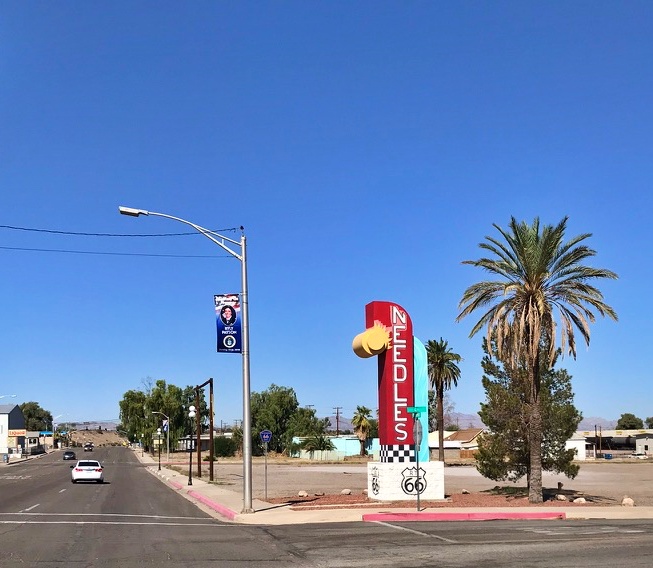
Welcome to Needles — the gateway town where Route 66 crosses into California from Arizona.
Cross the Colorado River from Arizona and Needles is the first town that greets you. Named for the jagged rock peaks visible along the border, first recorded during an 1854 railroad survey, Needles has been standing its ground in the Mojave heat since it was founded in 1883 as a stop on the Atchison, Topeka and Santa Fe Railway.
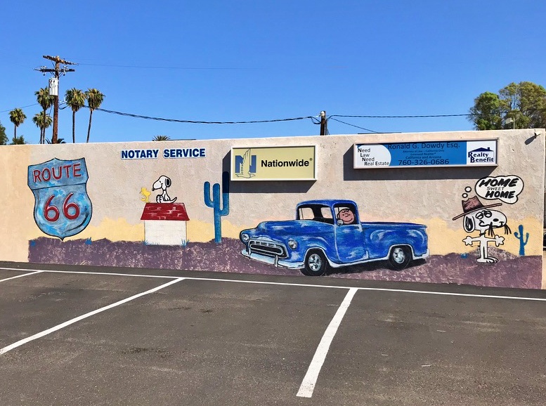
It’s also got an unlikely pop-culture claim to fame: Charles Schulz, creator of Peanuts, lived here briefly as a kid in the late 1920s, and the punishing desert he remembered became the setting for Snoopy’s desert-dwelling brother, Spike.
A Route 66 mural in Needles pays tribute to the town’s most famous former resident — Charles Schulz, whose childhood here inspired Snoopy’s desert-dwelling brother, Spike.
Needles shows up in The Grapes of Wrath, too — Carty’s Camp, a cabin court on the edge of town, appears as the Joad family crosses into California. This is a town that’s been quietly collecting stories for well over a century, and it deserves more than a drive-through.
66 Motel — Needles
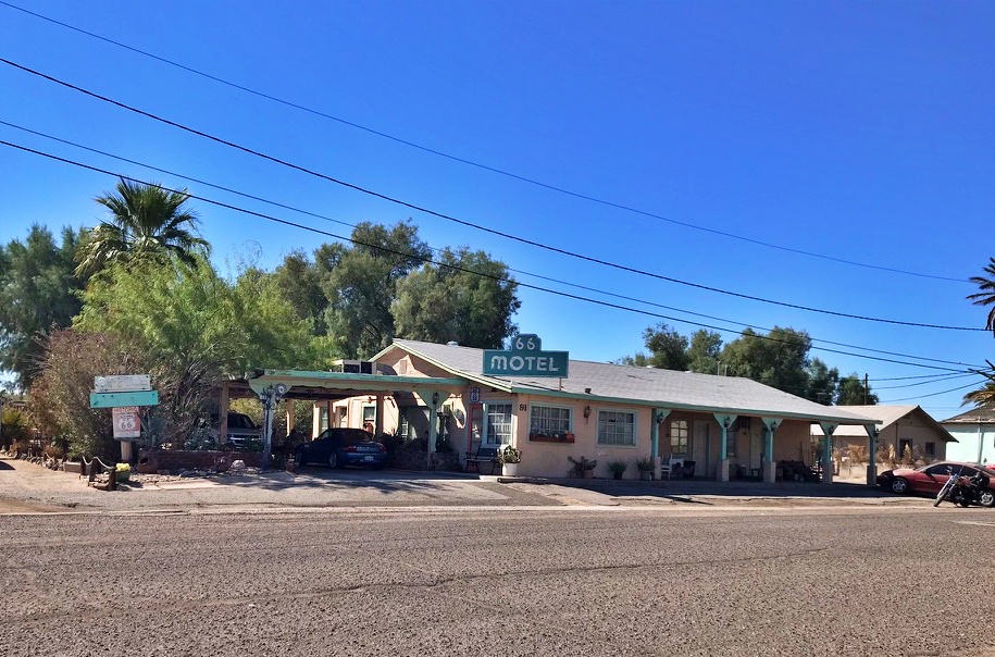
The 66 Motel in Needles, California — a tiny six-room motor court that’s welcomed travelers since 1946.
If you love the kitschy, unpretentious side of Route 66 as much as I do, this one’s for you. The 66 Motel has been sitting on this corner since 1946–47, a tiny six-room motor court that’s somehow dodged the wrecking ball for nearly 80 years. It’s not glamorous — it never was — but that’s exactly the point.
This is what Route 66 lodging actually looked like before anyone thought to call it “vintage”: a low strip of rooms, a hand-painted sign, and a name that just says what it is.
Needles’ Murals
More than any single landmark, what makes Needles worth the stop today is the murals. This is a town that decided if you’re going to have blank walls in the middle of the desert, you might as well make them loud.
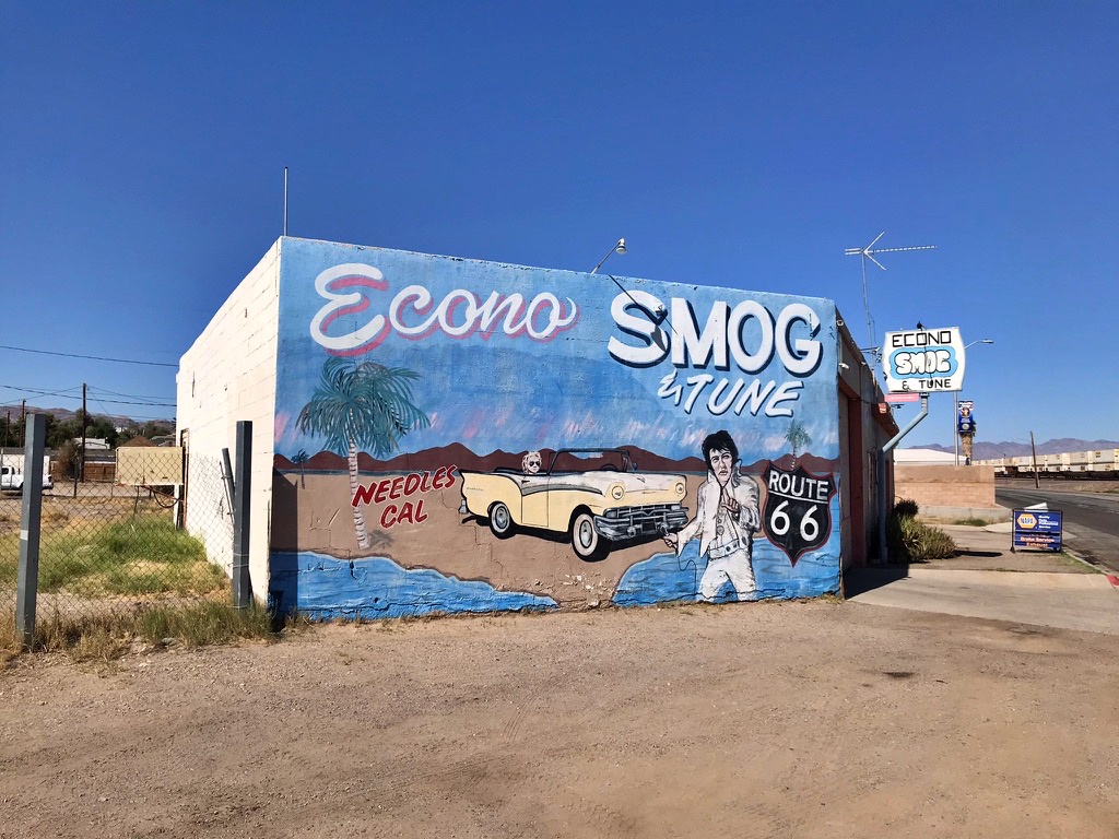
Econo Smog & Tune’s mural nods to a real, if easy-to-miss, Elvis connection: Needles gets a name-check in “Never Been to Spain,” written by Hoyt Axton and famously performed live by Elvis — “I headed for Las Vegas, only made it out to Needles.” Given Elvis’s own legendary Vegas residency just up the road, it’s easy to see why the song might have resonated with him enough to make it part of his live shows.
The mural pairs that lyric with a vintage convertible, a palm tree, and “Needles Cal” spelled out like a postcard, all painted across an auto shop of all places.
Econo Smog & Tune’s mural pairs a vintage convertible and an Elvis tribute with a “Needles Cal” backdrop — pure roadside kitsch.
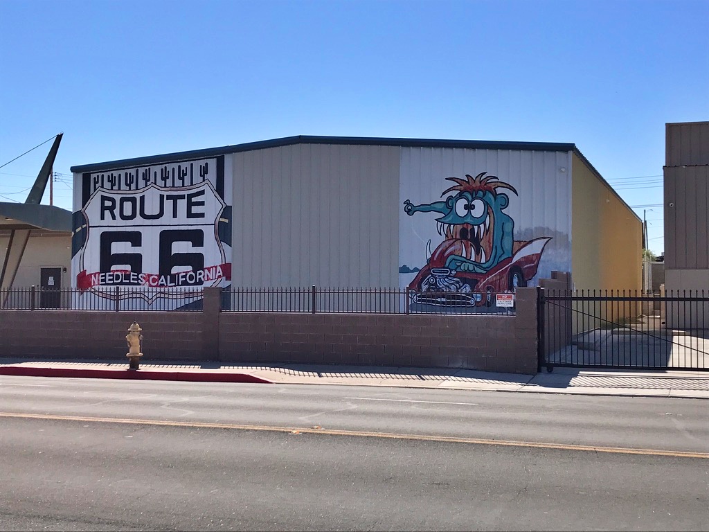
A few blocks over, a wild-eyed cartoon hot-rodder tears across another wall under a giant “Route 66 — Needles California” shield, cactus icons and all. This is exactly the kind of roadside-America weirdness that makes a trip down the Mother Road worth it — the kind of art that you find in towns that have a sense of humor about themselves.
A wild-eyed hot-rodder mural greets travelers under a bold “Route 66 — Needles California” shield.
Needles Theatre — Needles
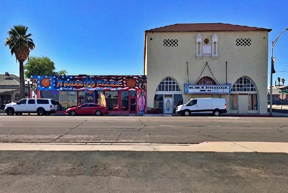
The Needles Theatre has anchored the corner of F Street and Broadway since 1929, doubling as a movie house and Masonic Temple in its heyday.
At the corner of F Street and Broadway stands the Needles Theatre, built in 1929 for a reported $60,000–$120,000 — an unusually grand sum for a little desert railroad town to spend on entertainment.
The building did double duty from day one: a movie house downstairs, a Masonic Temple upstairs.
It opened to the public on March 14, 1930, and kept the lights on for decades before a fire in the early 1990s forced it to close.
The Needles Area Chamber of Commerce bought it from the Masons in 1997 and started restoring the facade in 2002, and today it still anchors the same corner it has since Needles’ Route 66 heyday — pizza shop, Route 66 banners, and all.
Roy’s Motel and Cafe’ – Amboy
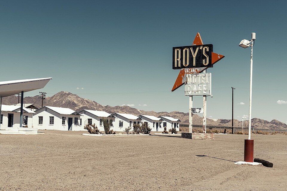
The towering neon sign at Roy’s has welcomed desert travelers to Amboy since 1959. Photo: Christopher Michel, CC BY 2.0 https://creativecommons.org/licenses/by/2.0, via Wikimedia Commons
Standing as a solitary sentinel in the stark expanse of the Mojave Desert, this mid-century oasis defines the isolated beauty of the early California stretch.
What began in 1938 as a modest gas station grew, through the following decades, into a full-service stop with a cafe, garage, and motel cabins — at its peak employing roughly a tenth of Amboy’s 700 residents. Its towering, 50-foot neon boomerang sign, erected in 1959 alongside its striking Googie-style lobby, acts as both a visual beacon and a monument to the golden age of American roadside culture.
When Interstate 40 bypassed the town in the early 1970s, Amboy nearly became a ghost town overnight, and the property changed hands several times before falling into foreclosure.
In 2005, it was purchased by Albert Okura — the same preservationist who saved the original McDonald’s site in San Bernardino — who pledged to restore Roy’s and keep Amboy from disappearing altogether. The sign, relit in 2019 after years of restoration, remains one of the most enduring and photographed symbols of the Mother Road.
Okura passed away in 2023, but restoration continues under his son Kyle Okura, who is working to reopen Roy’s motel cabins in time for Route 66’s centennial in 2026 — keeping alive the same spirit of preservation that first saved the McDonald’s site down the road in San Bernardino.
Elmer’s Bottle Tree Ranch — Oro Grande
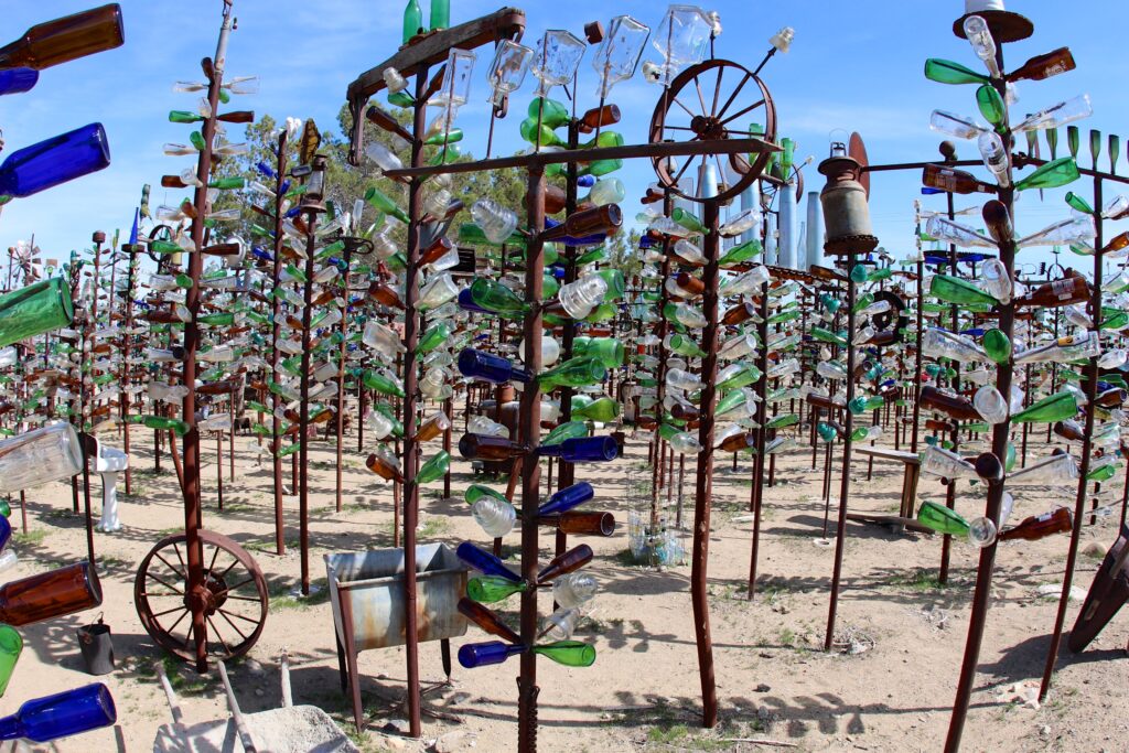
Folk art in the desert: Elmer’s Bottle Tree Ranch stands as a brilliant, whistling forest of vintage glass. Photo by daveynin, CC BY 2.0
https://creativecommons.org/licenses/by/2.0, via Wikimedia Commons
A wildly unique manifestation of roadside folk art, this stretch of the route features a dense, metallic forest built entirely from pipes and thousands of vintage glass bottles.
The ranch began in 2000, when creator Elmer Long — who had spent his childhood combing the Mojave Desert for discarded treasures with his father — welded his first bottle tree from the elder Long’s inherited collection.
What started as a single structure grew into more than 200 trees, each one also adorned with the kind of desert flotsam Long collected over a lifetime: old typewriters, street signs, and rusted car parts among them.
As the high desert wind moves through the clearing, the installation creates a distinct, echoing soundtrack that forces travelers to slow down and appreciate the creative, eccentric spirit that has always kept Route 66 alive.
Long passed away in 2019, but his family has kept the gates open, ensuring his handmade forest continues to greet Route 66 travelers free of charge.
Original McDonald’s Site & Museum — San Bernardino
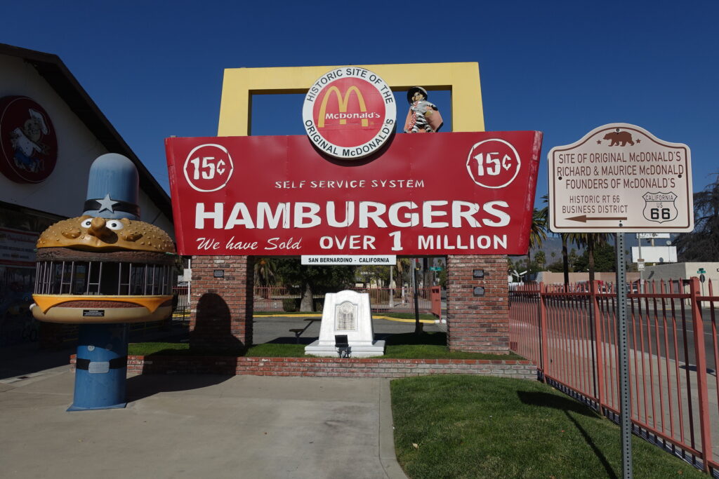
Original McDonald’s in San Bernadino by Jeremy Thompson from Los Angeles, California – San Bernardino, CC BY 2.0, https://commons.wikimedia.org/w/index.php?curid=97241350
This modest site marks the origins of one of the most recognized names in American culture. Brothers Dick and Mac McDonald opened their original restaurant here in 1940, and it was their decision in 1948 to strip the menu down to burgers, fries, and shakes that created the fast-food model still used today — years before Ray Kroc, the man most associate with the brand, even discovered the business. The original building is long gone, but the site now houses an unofficial museum, filled with McDonald’s memorabilia by the late Albert Okura. Its connection to Route 66 reflects how the road influenced everyday life and commerce far beyond travel itself.
Wigwam Motel – San Bernardino
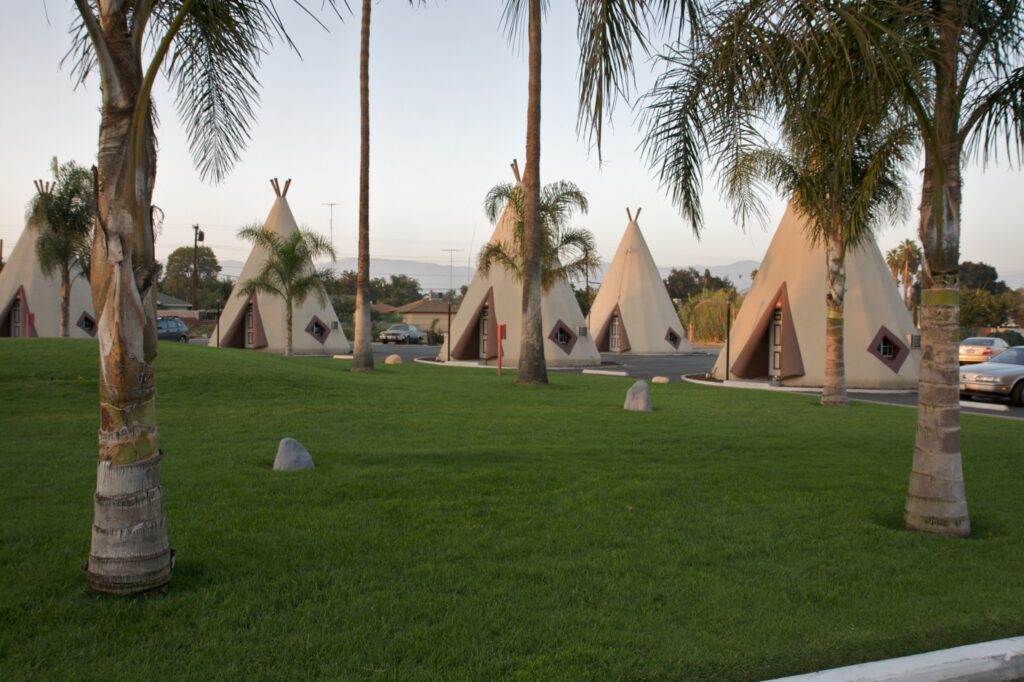
Mid-century roadside charm: The iconic concrete teepees of the Wigwam Motel have offered a unique rest stop for Route 66 travelers in San Bernardino since 1949. Photo by Marcin Wichary, CC BY 2.0 https://creativecommons.org/licenses/by/2.0, via Wikimedia Commons
Constructed between 1947 and 1949, this was the seventh and final Wigwam Village built by designer Frank Redford, whose whimsical teepee-shaped motels once dotted highways from Florida to California. Today it’s one of only three surviving Wigwam Villages in the country — and the only one in California.
After decades of decline, the property was lovingly restored by the Patel family starting in 2002, and its 19 concrete-and-stucco wigwams, arranged around a central pool and courtyard, still offer travelers a chance to sleep the way road-trippers did in the 1950s.
Its distinctive silhouette is often cited by fans as a likely inspiration for the Cozy Cone Motel in Pixar’s Cars, another nod to how deeply this stretch of highway shaped American pop culture.
Listed on the National Register of Historic Places, it stands as a living testament to the whimsical landmarks that converted a simple highway corridor into an unforgettable American destination.
Santa Monica Pier — Santa Monica
By the time Route 66 approaches the coast, the experience has changed completely. The emphasis is no longer on distance covered, but on arrival—on the awareness that the road is nearing its end.
This portion of the route carries a different energy. The emphasis is no longer on what lies ahead, but on what has already been traveled. The road becomes reflective, shaped by its destination as much as its past.
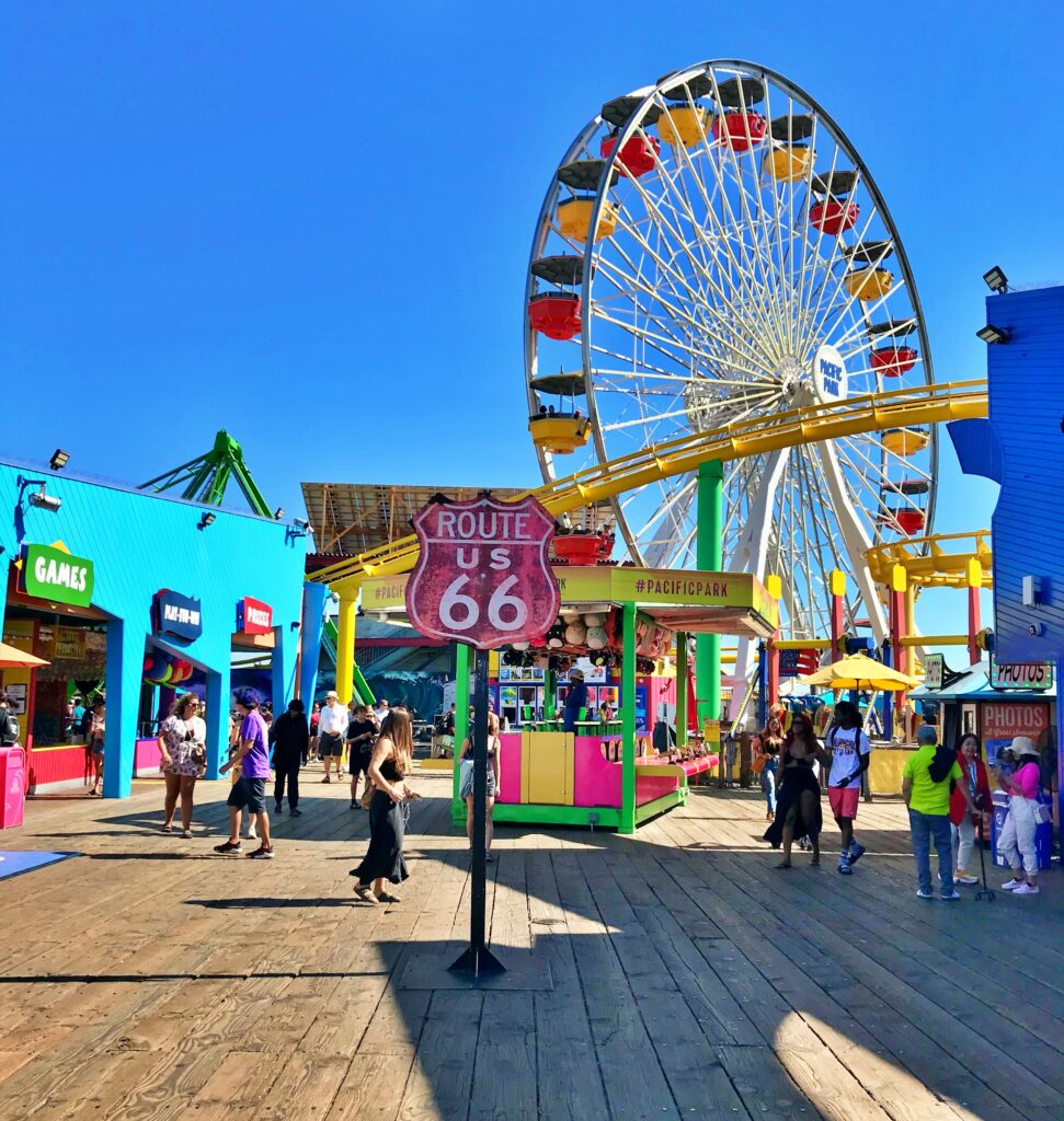
The end of the trail: Route 66 meets the vibrant energy and coastal sunshine of the Santa Monica Pier.
The Santa Monica Pier is often called the western end of Route 66, but the highway’s true historic terminus lies about a mile inland, at the intersection of Lincoln and Olympic Boulevards — the spot federal regulations required so the route could connect to the Pacific Coast Highway rather than simply run into the ocean.
The Pier’s now-iconic “End of the Trail” sign wasn’t installed until 2009, on the highway’s 83rd anniversary, when preservationists and local boosters decided the Mother Road deserved a more scenic, symbolic send-off than an unremarkable intersection.
Whatever the technicalities, the choice worked: today, the Pier is where most travelers actually go to mark the end of their journey, posing beneath the sign with the Pacific stretched out behind them. It represents both a literal and symbolic conclusion — not because the road ever really ended here, but because this is where the idea of Route 66, mythologized by song, film, and decades of American road-trip culture, finally meets the ocean it was always racing toward.
Roadside Culture & Landmarks
Route 66 culture in California shifts from roadside identity to integration within a broader urban and coastal environment. While historic stops and signage still exist, the road becomes less defined by individual landmarks and more by its place within the larger story of American travel.
This stretch reflects both preservation and adaptation, where the road continues to exist even as its surroundings evolve.
Traveling Through California
Traveling Route 66 in California involves a steady transition from open desert driving to dense urban navigation. Distances between towns give way to continuous development, and the pace of travel shifts accordingly.
The final portion of the route, particularly through Los Angeles, is shaped by traffic patterns and city layout more than by the road itself. While this contrasts sharply with earlier stretches, it reinforces the reality that Route 66 has always adapted to the spaces it moves through.
Approaching the coast, movement slows—not because of distance, but because the journey is nearing completion. Route 66 doesn’t simply end at the ocean. It becomes an arrival shaped by the distance traveled and the experiences gathered along the way.